The townships, on the north side of the Calder, were named Stansfield,Heptonstall,
Wadsworth, Midgley, Warley, Ovenden, Skircoat, Halifax, Northowram, Southowram,
Shelf, and Hipperholme-cum-Brighouse: and those on the south side Langfield,
Erringden, Sowerby, Soyland, Rishworth, Barkisland, Norland, Stainland, Elland-cum-Greetland,
Fixby and Rastrick.
The townships were in existence in Anglo-Saxon times and they were unchanged
upon the Norman Conquest. The word township ordinarily implies what we should
to-day call a civic area, and is a much older term in England than parish
which signifies an ecclesiastical division. Midgley Township is situated
about the north centre of this enormous parish of Halifax that embraces all
the upper waters of the Calder, its tributary vales and cloughs and the hills
and moors flanking them, for some thirteen miles along the river on either
side from Brighouse to Todmorden, an area of more than 124 square miles.1
The western border of the Parish marches along the top of Blackstone Edge1
on the Pennine Range, with the Lancashire parish of Rochdale.2
Situated on the rather inhospitable Pennine Range the Parish of Halifax in
the West Riding is, as it were, on the slope of a roof, below the eaves of
which lies the great Plain of York extending from the Pennines to the coast.
The easiest and most direct route between the south and the north of England,
from London to York and thence to Scotland, is along this plain and not over
the hills. Thus as a result of its somewhat out of the way situation
Halifax has no record of Royal visits or of any spectacular prominence in
English political history.
Much of this Parish district, now long sub-divided and filled in many hilly
depths with grim and ugly factories, is constituted of vast tracts of Pennine
moorland, the solitude of which is hardly interrupted by the innumerable
little farms that cluster round its border.3 I can still
imagine hearing the larks singing as they soared out of sight above me while
I walked one summers day more than half a century ago from Druids1
Altar, Bingley, across the moors above Midgley to Halifax.4 Writing
in his Journal in the middle of the 18th a century and before the coming
of steam power, John Wesley noted that nothing since the Garden of Eden could
be more pleasant than Calder Vale between Todmorden and Heptonstall, and
he had seen more of England than any other man of his time. He could have
included other parts along the Upper Valley where the scenery is still beautiful,
indeed not a few of the glens in upper Calderdale remain unspoiled and romantic
in character.
In the north and west of the Riding are the dalesmen who wring their hard
living from the Pennine fells and valleys. The most characteristic sight
in the greens and greys of the dale country is a shepherd setting out with
his dog to round up the sheep from the fells which enclose the dales.
In the lower lands of the Aire and the Calder are the woolmen converting
the fleeces, home and imported, into clothing. And further south upon
and around the Don are the men of coal and iron in the 'Black' industrial
country of Yorkshire.5
In general the North of England was sparsely populated in earlier centuries
for lack of the means of subsistence. Where the soil was good, there were
the most inhabitants. In the later Elizabethan Age water-power facilitated
the clothing manufacture of the West Riding and led to an increase in population.
Where it was possible township boundaries followed marked physical features,
and where these did not exist cairns and isolated stones were erected at
intervals. Old Midgley Township is of peculiar shape, something like a long
rectangular figure which has been bent. The longest distance runs from
the Calder Valley northwards rising steeply for five miles to Oxenhope Moor,
whilst the widest part extends for some three miles along the Calder River
in the south, where the boundary on the west is Foster Clough, separating
the old townships of Midgley and Wadsworth, and on the east, Luddenden Brook,
separating the old townships of Midgley and Warley. Both these streams flow
into the Calder itself. The boundaries which are clearly described in several
reports of 'beating the bounds' need not concern us here.6
-6-
Old Midgley Township has for more than two centuries past comprised half-a-dozen
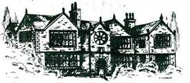
hamlets, namely Midgley itself once known as Midgley Town, with its two 17th
century old residences Cliff Hill (built 1601) and Great House, and also
Lydgate, Thorney Lane, Booth, Providence and Luddenden. Nowadays when someone
says I am going up Midgley" he usually means Midgley Town some five hundred
feet above the valley bottom. Indeed the rise up Old Lane on to Heights
Road, the old pack-horse route along the hillside, is quite steep. Before
A. D. 1700 and the growth of the hamlets there were old settled holdings
along the lower reaches or slopes of the Township at White Lee, Ewood, Brearley
(Hall 1636), Ellen Royd, Greave House, Luddenden Foot, Kershaw House (1650),
Luddenden. Oats Royd and Dean House. Below the circumference of the moorside
and round about Midgley itself, Lydgate and Thorney Lane, are still old holdings
extending from Han Royd, Green Royd, New Heath Head, Scotand, Tray Royd,
Lees, Gate House up to Height. From 1600, as indicated by the dates, many
of the old fam buildings were rebuilt as the owners prospered.7
The total area of the Old Township is about 2,600 acres, and almost two-thirds
of its roughly rectangular shape is moorland waste rising up to near 1,500
feet and impossible to cultivate. Being in the centre of the Pennine Range
it is particularly wind and rain-swept and mostly bleak and exposed.
Like the rest of Halifax Parish the ground is stony, the soil thin, and from
earliest recorded time small farmers eked out a living by weaving their own
sheep's wool. The region is almost all sloping land. very steep in
parts along the Valley bottom but every quarter mile or so it has a sort
of steps, fairly broad shelves of ground between moor and wooded valley,
and these have been the cultivated parts from old time, For example, if we
ascend the northern bank of the valley at Brearley, we find the old town
of Midgley and its farms situated on a terrace between Brearley Wood and
Midgley Moor.
There are a few exceptions to this rule in Halifax Parish. Mytholmroyd is
an old settlement on the floor of the Calder Valley. The oldest portion of
the town of Halifax is at the bottom of the hill. But. generally speaking,
the whole of Calder Vale and the branch valleys showed these three distinct
bands of wood, farm and moor. That is the reason why most of the older
hamlets are high up on the hifls. Heptonstall, Sowerby, Midgley, Illingworth
in Ovenden and Rastrick were formerly the centres of trade.and population,
and held pre-eminence until the eighteenth century and the coming of the
Industrial Revolution when the mills provided work in the valleys, which
were formerly no-man's-lands.
It is unlikely country for farming if one is used to the rolling, flat acres
of the plain of York or the sweeping regular lands of the great farms of
the Midlands and South, yet farming has been going on for many centuries on
these upper reaches of the Calder Valley. These farms are mostly very small
by the standards of other counties but there is enough work to keep the farmer
and his wife fully occupied throughout the year. Formerly under the
domestic system, as will be noted. many of these families also worked at
their looms. The valley of the Calder River along the slopes of the southern
boundary of the Township has long been one of the great highways to and from
Lancashire, and the bottom has during the last 200 years been comptetely
developed and industrialised.
Nestling deep at the foot of Midgley Township hillside the village of Luddenden
to-day retains an old world charm. Through the centre of the village
runs the boisterous Ludd stream which still bears unmistakeable traces of
the early harnessing of water. Entering the village one comes to the
14th century corn mill. From the Square one passes over the Ludd stream
up the narrow twisting road between the Church in its beautiful sylvan setting
and the Lord Nelson Inn opposite, the Old Swan 1634, which was long the meeting
place for all parochial affairs.8 An interesting feature of the
building is that it was once used as a library as early as 1776 and was one
of the first subscription libraries in the North of England.
Leaving the Inn one immediately begins the ascent of Church Lane
-7-
and Old Lane, one of the steepest in the district, up through Lydgate to
Old Midgley Town and Heights Road on the higher reaches below the moor.
Old Lane and Heights Road joined up in the distance with the long Causeway,
an ancient byway linking Whalley in Lancashire with Halifax, via Burnley,
past Blackshaw Head, Heptonstall, 9 Hebden Bridge, and Heights Road in Wadsworthand
Midgley. Travellers on foot and pack-horses made this road which was
never intended for vehicles. At Lydgate Thorny Lane leads off round
the hill to [II] Booth where farmer Arnold Midgley presently in the reign
of Elizabeth [II] wrests a living as his forbear Samuel Midgley used to do
on this same hillside of one-in-six in the days of Elizabeth I.
In the area of the Township are all the fine old17th century homesteads, and
also the large Murgatroyd mill where Ronald the last male survivor of a long
line still produces some of the best worsted cloth in the West Riding.10
Though Midgley Township is situated on the northern side of the upper reaches
of Calderdale it is.not popularly regarded as belonging to the Dale country.
The southern fringe of this region is generally placed about Skipton in upper
Airedale, from which Midgley is somewhat isolated by a dozen miles of high
moorland. Strategically Skipton occupied a commanding position at the
eastern approach to the Aire Gap, that singular depression in the Pennines
about 500 feet above sea level, the easiest Pennine crossing into Lancashire
and
therefore the richest in history. As long ago as B.C. 2,000 Bronze Age
traders dealing in gold from Ireland, and in copper and tin, as well as smiths
and crafts-men learned in the mysteries of metal work used it as a direct
cross-Britain route to Scandinavia. They left many a mark of their
passing in lost palstaves, swords and flat bronze axes. On the rounded
knolls are barrows for their dead and on Rombalds Moor are stones bearing
marks of their sun worship. Each succeeding wave of newcomers swept
through the Gap, which was a far shorter, more direct and less dangerous
route than the sea way round Britain past Cape
Wrath.11
There is no doubt about its being soaked in history, and in the blood of
fighting men who in the Aire Gap either bravely battled to win it or defend
it. Sometimes dalesmen held back the Scots here, or were forced back to Skipton.
Yorkists and Lancastrians fought through the Gap during the Wars of the Roses,
and in the Civil War of the 17th century both Royalist and Parliamentary
armies made good use of this easy crossing from Aire to Ribble. Even
if Calderdale and Midgley in particular, did not always become involved in
the full course of
events in Airedale, their effects must have been felt from time to
time. After all, the Aire towns Keighley and Bingley were only some
half-a-dozen miles distant across the moors from Midgley Township. It
is noteworthy also that two Roman roads crossed close by the township.
The principal one proceeded from Manchester over the Pennines across Blackstone
Edge into Calderdale, continuing via Keighley to the great camp at flkley
in Wharfedale to join the road to York, The other served as a link road
from Colne joining that from Manchester to York via lower Calderdale.
Some account of the beginnings, development and growth of human settlement
in the West Riding of Yorkshire may prove of Interest. The vicissitudes
experienced by its inhabitants down the centuries, coupled with rigorous climatic
and natural conditions, and the resultant constant struggle to survive, may
serve to explain the make-up of our dour Yorkshlreman, the basic ingredients
from which the oft but unjustly maligned 'Yorkshire tyke' has been
compounded.
Lest the above description of the West Riding between Aire and Calder be
lacking in verisimilitude and intimacy, I commend the novels of the Bronte
sisters to the reader. Charlotte, Emily and Anne were born at Thornton
near Bradford in the East of the area and their writings are based largely
in the Haworth district in the West where their father was perpetual curate
from 1820 till his death in 1861. "Here Yorkshire and Lancashire meet in
a wild tumult of windswept hills where fleeting sunshine chases cloud shadows
and sudden rain sweeps ike a falling curtain over the landscape".12
5. Not to be confused with the Black Country of South Staffordshire
6. Twelve peregrinations by the parson and choir with switches round the boundaries where landmarks (and the boys) were beaten in the interest of remembrance and tradition.
7. The first break into the Old Township as above described came in 1868 when Luddenden Foot Local Board was formed out of portions of Midgley and the old neighbouring townships of Warley and Sowerby. That part which went to Luddenden Foot was from Upper Foot to where the brook enters the Calder, up Luddenden Lane to Kershaw House on the West side to to Ellen Royd and down to Upper Foot. Then in 1892 on the formation of the Mytholmroyd Local Board out of portions of Midgley and the old neighbouring townships of Erringden, Sowerby, and Wadsworth, Mytholmroyd took from Midgley, that part of Scout Head to Foster Clough and downstream to Clough Bottom, along Calder to Upper Foot and Luddenden Foot, including Ewood, White Lee and Brearley. Finally Midgley lost its local authority when, as from April 1st, 1939, it became a ward of Sowerby Bridge Urban District Council.
8. Branwell Bronte used to visit the Lord Nelson Inn down in Luddenden when he was a station master at Luddenden Foot station. Mrs. Hannah Thompson of Carr Field, Luddenden, who died in 1905 and whose uncle was Dr. John Mitchell, the Brontes' family doctor, used to recall how she visited Charlotte and how Branwell had boils and she used to dress them for him.
9. Heptonstall is a quaint and picturesque village across the Hebden Valley
from Wadsworth and Midgley.
10. The Murgatroyds were an old Calderdale family, like the Midgleys, and
originally sprang from a clearing, moor-gate-royd, near Warley Moor at Holins.
Branches also spread into Airedale See page 48. The mill at Oats Royd was
founded by John Murgatroyd in 1840.
11. Rombald's or Rumbles Moor in the divide between Airedale and Wharfedale or between Bingley and Ilkley.
12. Geoffrey Coning's large colourful map of the Bronte Country which includes
so many places mentioned in this narrative cannot, regrettably, be reproduced
here. It is my belief that a man takes on the protective colouring of his
environment as do the lower animals. In the bleak regions he inclines to
become dour, silent and perhaps a little melancholy. I'm not saying that
our part of the West Riding is not beautiful at times in all seasons, but
these can be of comparitively short duration and the balance of the time
does not then incline a man to laughter and gaiety.
| %%%%%%%END OF CHAPTER 1 MIDGLEYANA %%%%%%% |
![]() Index Page
Foreword
Next-Chapter 2
Notes
Index Page
Foreword
Next-Chapter 2
Notes