 |

|
Robin Hood search for the Truth | Robin Hood Places | Hood surname statistics | Robin Hood of Wakefield | Robert Hood of Newton | The Pinder of Wakefield | Marian | Friars | Loxley and 'Huntington' | Myriads of Robin Hoods | Ballads of Robin Hood | Kirklees | The Armytages of Kirklees | Little John | Roger De Doncaster | The Penurious Knyght | Our Comly King | Shire Reeve | Priory of Kirklees | Wakefield Rolls | Saylis of the Geste- a new site | Robert III Butler of Skelbrooke | Barnsdale and the Geste | De Lacis of Pontefract | Alice De Laci and John of Gaunt | Barnsdale Gallery | A suspected compiler of the Geste | Images of Robyn Hode
|
|
An Alternative location for 'Saylis' of the Geste For about thirty years, Dobson and Taylor's conflation3 that the 'Saylis' of the Geste set in Barnsdale was situated at Sayles Plantation, Wentbridge, has gone unchallenged. Holt2 says, "Sayles, as Hunter showed1, was a tenancy of the honour of Pontefract and the name, as Dobson and Taylor pointed out, still survives in Sayles Plantation". As such 'Saylis'* in the Geste has been identified by Dobson and Taylor as a plot of ground overlooking the highway on the northern edge of 'Barnsdale' originally consisting of one tenth of a knights fee. * Also Sayles in the Geste. Dobson and Taylor give credit to Joseph Hunter for identifying the 'Saylis' of the Geste with Sayles, "a small obscure tenancy of the late medieval manor of Pontefract." This record appeared as a feudal contribution granted to Edward III in 1346-1347 for the knighting of his son, the Black Prince.However as Dobson and Taylor state, 'Hunter and his successors never established the exact whereabouts of the late medieval Sayles'. A look at the Ordnance Survey map of Wentbridge for 1853 has the area designated as 'Sayle's Plantation' on modern O.S. maps and by Dobson and Taylor [1976] as being named 'Smeaton Pasture Woods', this map was produced at about the same time that Hunter was publishing his ideas. Hunter may have known this and therefore could not designate 'Saylis' as the 'Sayles Plantation'. Hunter never located the 'Saylis' of the Geste near Wentbridge, it was Dobson and Taylor who did so, for they continue "Never a village nor apparently even a hamlet, the name and location of Sayles, a landholding within the Parish of Kirk Smeaton, has yet survived almost unchanged to the present day." An acre in the 'Sailes' listed in a Kirk Smeaton glebe terrier of 1688 can be safely identified with the plot of land referred to as 'Sailes Close' almost two centuries later in a glebe terrier of 1857".10 This disparity in naming wooded areas is not isolated to this example in the vicinity of Barnsdale. On modern O.S. maps, what is labelled 'Barnsdale Wood', east of Barnsdale Bar, was in 1854, called 'Dove Wood' and 'Oak Wood'. Dobson and Taylor [1976] are brought to task by Prof. J.C. Holt [1982] in their location of the 'Stone of Robert Hode', mentioned in a deed of 1422 from Monk Bretton the former Cluniac priory. " J.W. Walker jumped to the conclusion that this was the site of Robin Hood's Well.... and he has been followed by all subsequent writers." Holt continues "The stone must have been much nearer to Barnsdale Bar and to the west, not the east of the Road, for it was sited in the fields of Sleep Hill [Lynges of Slepil] abutting the Ings of Skelbrooke between the village and Wrangbrook. At all events, here was a boundary stone or guidepost, less than a mile south-west of Barnsdale Bar, which in 1422 carried the same name as the local outlaw hero." This stone is the earliest recorded reference to the ballad hero in Britain. Equally the precise area covered by 'Barnsdale' is debateable, some claiming it is a large tract of land between Doncaster and Pontefract, others a more confined area pivoting about what is today called Barnsdale Bar. Barnsdale Bar lies at the top of a long incline northwards along 'Watling Street' rising some 40 metres [30 to 70m] from the valley of the Skell near the site of Burghwallis Roman auxilliary fort and 'Robin Hood's Well'.
This long arduous slope of the main road north onto the Magnesian Limestone ridge, it could be argued, has been one of at least two excellent points in this area during the past for the interception of travellers on the highway. Additionally, the convergence of two Roman roads, one from the Templeborough -Doncaster Road and the other from Doncaster, provides an even greater advantage in relieving travellers of their possessions. There is still a local oral history that Robyn and his men watered their horses in the Skell and grazed them in what is now a field above Wrangbrook House. The
Roman road to
the
Templeborough
[Definite and
probable Roman
roads in the
locale of
Skelbrooke and
Doncaster] -
Doncaster road
can be traced
south from
Skelbrooke
along
Straight Lane,
disappearing
across Hampole
Dike but can
then be traced
along a sunken
way, Old
Street, then
Lound Lane,
Straight Lane
[Street Lane]
again, then
seems to
follow a line
of trees
before it
appears to cut
across a field
to Hangman's
Stone Lane.
From here it
is untraceable
except
possibly on
Melton Mill
Lane after
which it
crossed the
rivers Dearne
and Don at
Dearne Bridge
and Old Denaby
respectively.
A close examination
of Ordnance Survey maps for 1853 in the Barnsdale
area suggests another site, other than Sayles Plantation,
may lend more credence to the idea of 'Saylis'
being further south. This 'Saylis' overlooked our more
confined definition of Barnsdale, that is, what is specifically
proposed here to be the valley of the Skell. This concurs
with J.C. Holt's suggestion that Barnsdale was likely to be
the valley of this brook. As Dobson and Taylor point out, 'Beorn's
Valley' scarcely occurs as a topographical name before the 1400's
and owes nearly all its prominence to the Robin Hood legend. In
our proposition here, Barnsdale is then a dale, 'Beorn's Dale',
which is oriented generally upstream towards Barnsley, 'Beorn's
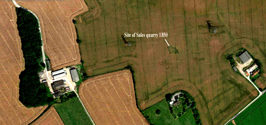
Ley'. The new proposed site for 'Saylis' is situated where
Sales Wood and Sales Quarry were located
between [Barnsdale] Summer House and Woodfield House off New
Close Lane. The names, as with the physical entities, Sales Wood
and Sales Quarry, now seem lost to cartographers.
This extract from the Geste of Robyn Hode indicates that the three outlaws went to Saylis [proposed here as Sales Wood mentioned in 1853], they could not see anyone to the east or west but looking south into the valley of the Skell [which we now deem is the original Barnsdale] they saw a knight [Sir Richard Atte Lee] riding his horse along a side street towards the main highway, locally called "Watling Street", actually a branch of Ermine Street. Today this side road would be recognised as New Close Lane, probably an eastern extension of Bannister Lane* , New Close Lane leads to Campsall, Norton and Walden Stubbs. Prof. J.C. Holt emphatically asserts, after describing that the valley of the Skell is likely to be Barnsdale, "But the Gest has another connotation, for there can be no doubt that when Little John stood at Sayles and 'loked into Bernsdale', he was looking at Wentbridge lying in the deeply cut valley of the Went". These two statements seems to confound each other and assume that Barnsdale is the Went Valley or the Went valley is the northern extension of Barnsdale. In our modelling here we do not agree with this notion, but recognise that Barnsdale is a much more localised topographic entity. As Dobson and Taylor point out [1976, p. 17], 'Robin Hood of the Geste was an intensely local hero figure'. * Bannister or Banistre derives from a family here in the 1100's. Thurstan II de Banastre held lands near Hampole and Skelbrooke in Barnsdale. He provided land for the establishment of the nearby Hampole Priory.
Since recognising that the high ground north of Skelbrooke was the site of Sayles Wood in the 1850's, some have questioned whether this name was in existence in earlier times. Indeed we find that the name 'Skelbrok by le Sailes' appears in a post mortem for August 1298 when it was shown that Skelbrooke had a windmill. It is contended here that this windmill was sited at the most exposed part of the high ground (above the 70 metre contour) which is where Summer House Farm is located today. At this point the sails of the windmill would catch the wind from any direction. As a prominent landscape feature it is also predicted that the Skelbrooke windmill would have been a common sight for travellers on the locally called 'Watling Street', essentially the A1 today. The sails of the windmill being visible for many miles probably gave rise to the name 'The Sayles' or as recorded in 1295, 'le Sailes'. Below is a composite view of what a medieval windmill on the Sayles might have looked like, viewed from the south.
Apart from a mill at Skelbrooke, the workers of the Templars mill at Burgh Wallis* on the river Skell near Skellow may have been
the inspiration for Much the miller and his father. The author of the
Geste is likely to have drawn inspiration for his characters
from contemporary life. We find that Adam Le Waleys of Skellow was mentioned
as part of Robert III Butler's group of thieves and receivers, who, if
he was of Henry Le Waleys' descendancy, could have been resident on
the site of what is now Skellow Old Hall in Old Skellow or 'Cromwell's
Batteries' where it is likely that a former motte and bailey stood. in
the late1290's. It might be noted that 'Thomas, chaplain of Skelagh,
formerly living at Doncaster' is also mentioned in the list of thieves
and receivers. * This water mill dates from 1185 which coincides
with the date for the earliest recorded windmill in England near Skidby,
Yorkshire.
The region boasts of a large number of 'plantations', well shown on Ordnance Survey maps of 1853 and 1854. As their name implies these seem to have been purpose planted areas and as such are relatively recent features on the landscape. They are often named after local places or surnames, one such local surname is Sales [Sayles/Sailes/Seels]. An analysis of the surname Sales from the 1881 census shows that out of the earliest sample of 200 of 879 individuals born in Yorkshire of that name, the anomalies were: Sheffield with 27 individuals, Crowle 13 [28 miles east of Barnsdale on marshland now drained] Hull 9 Hooton Pagnell 7 Doncaster 6 Little Smeaton 6 Scarborough 5 Apart from Little Smeaton and Hooton Pagnell, places within 'Barnsdale' are Darrington 2 Hampole 2 Burghwallis 1 Wentbridge 1 We can discount Sheffield, Hull, Doncaster and Scarborough as they are centres of population attraction, this leaves Crowle which was developed after the marshes were drained. Within the broader definition of Barnsdale, Little Smeaton and Hooton Pagnell stand out. It would seem that even as late as 1881 there was a nucleus of individuals carrying the name in the area and there can be little doubt that one of these filial nuclei was the source of the names for both 'Sayles Plantation' and Sales Wood and Quarry. In both Sayles Plantation and Sales Wood, Little Smeaton is the closest when compared with the distances to Hooton Pagnell. This suggests that the owners at some time were the Sayles family whose descendants were still resident in Little Smeaton in 1881, where one head of a household is found to have an occupation as a woodman. We might also note that a person by the name of Sayles is found to live in Skelbrooke in 1293:
 Jake Sales of Axholme finds that in the Dictionary of English and
Welsh Surnames the name Sayles [Sailes, Sales etc.] is a Yorkshire
name meaning the upright stakes of a hurdle. Hurdles were often constructed
from birch and woven willow to pen sheep in a structure called a pinfold.
Jake reports that other persons by variants of this name are mentioned
in 1379 e.g. Agnes Del Sayles, William Salys, Alanus Sayle, Willelmus Saylles.
Jake Sales of Axholme finds that in the Dictionary of English and
Welsh Surnames the name Sayles [Sailes, Sales etc.] is a Yorkshire
name meaning the upright stakes of a hurdle. Hurdles were often constructed
from birch and woven willow to pen sheep in a structure called a pinfold.
Jake reports that other persons by variants of this name are mentioned
in 1379 e.g. Agnes Del Sayles, William Salys, Alanus Sayle, Willelmus Saylles.Sylvan Vegetation of Barnsdale One other association Saylis is said to have is with the name of willow tree or Salix sp. If we look along the banks of the Skel today we would not find it difficult to quickly locate Crack Willow [Salix fragilis] on both sides of the Skel. In fact Skelbrooke village had osier beds in the past where willow was collected to make baskets [the 'Osiers' are marked on the 1850's O.S. map just east of Robin Hood's Well.]. Jeffrey Stafford has suggested the 'Sayles' were named after a windmill and there is now evidence for this construction and the fact that a William del Sayles lived in Skelbrooke during the late 1200's suggests it is called after this family name or more likely his surname was taken from the prominent and well-known landmark. The linden tree [common lime] often mentioned in the early ballads of Barnsdale can be found in grandeur outside Skelbrooke Church, with large Ash and Sycamore at Skelbrooke Hall.
1. 1225 - At Sayles also Sales - The prior of Worksop had 36 acres in
'Saylles'
granted to him
by king Henry
III because a William son of Thomas had abjured the land because of
murder. [C.Cl. R., 9 Hen III,
m. 21; Y.A.J., vol 12, (1893), p.
65; TNA, C54/3, m.
31.This occurs
under 'Sayles
als Sales' in
the Y.A.J.
Although this
does not
locate Sayles,
it indicates
that the name
was already in
use. 2. From the YAJ vol.; 12, (1893), pp.
68-69: 'The Wapentake of Osgoldcross' by
Richard Holmes
- a footnote
under 'Skelbroke
als Scelbroke
nere Sayles'
in the
Yorkshire
Archaeological
Journal
supportively
states: 3. 'Skelbrok by le Sailes' appears in a post mortem for August 1298 when it was shown that Skelbrooke had a windmill.
Sources: 1. Hunter, J., The Great Hero of the Ancient English Minstrelsy of England : Robin Hood, his period, Real Character etc., Investigated and perhaps Ascertained, Critical and Historical Tracts No. 4, London, 1852, reprinted Worksop,1883.---- The Ballad Hero : Robin Hood, London, 1852. 2. Holt, J.C. Robin Hood, Thames and Hudson, 1982, pp. 83-86. 3. Dobson, R.B. and Taylor, J. Rhymes of Robin Hood : An Introduction to the English Outlaw, Heinemann, London, 1976, pp. 22-23; also Alan Sutton, Gloucester 1989 revised 1997. 4. Ordnance Survey map of Barnsdale area 1853. 5. Ordnance Survey map of Wentbridge area 1854. 6. Google Earth base photo mosaic, modified with place-names. 7. Faull, M.L. & Stinson M., Domesday Book for Yorkshire. Pt. 1, Phillimore, Chichester, 1986. 8. Mills, A.D. Dictionary of English Place-Names.O.U.P. 1991. 9. Camden, William. Brittania.1607. 10. Borthwick Institute of Historical Research, St. Anthony's Hall, York. R. III. F ixlvi b; R. III F. 16 xlvi [Kirk Smeaton Glebe Terriers of 7th June 1688 and 10th June 1857]. 11. Frere, S.S. et. al. Tabula imperii Romani - Britannia Septentrionalis. London. 1987. Copyright © Tim Midgley 2006, additions 29th July 2018. Internal links revised July 2023. |


 From an above aerial
photograph we note the location, of what came to
be known as the "Bishop's Tree" or "Robin Hood's Oak" and
later the "Bishop's Tree Root" at the junction of the two Roman
roads. From a lighter coloration on the aerial photograph,
the site of 'Watling Street' seems to be slightly west of
the present A1.
From an above aerial
photograph we note the location, of what came to
be known as the "Bishop's Tree" or "Robin Hood's Oak" and
later the "Bishop's Tree Root" at the junction of the two Roman
roads. From a lighter coloration on the aerial photograph,
the site of 'Watling Street' seems to be slightly west of
the present A1. .
.
.
.